|
History
Lake
Iroquois
Our area lies on a glacial geological feature
called the Lake Iroquois shoreline. Lake Iroquois was a lake formed at the end of the
glaciation by melting glacial ice in the Lake Ontario basin. At that time, the St.
Lawrence River valley was blocked with ice and the lake level rose above present day Lake
Ontario, actually draining southeast near Syracuse, New York. The shoreline is typified by
washed sand and gravel beach bluffs, lying on the flanks of the prehistoric Bowmanville
Till plain. As the melting ice water entered the lake, the courser and heavier soil
particles settled out first leaving a band of sandy soils in shore area. Further offshore
the soils become progressively more fine grained. There is less coarse sand and the soil
materials grade to a silty fine sand and even to a fine sandy silt. In the deeper water
areas, where there was little water movement, there are deposits of fine grained clays and
silts. All of these area overlie the former till ground surface. The shoreline did move
with time as more material was deposited and the lake receded, so these same coarse
materials can be found at differing distances from the present location of the beach
bluffs . With each recession of the shoreline to the south the "nearshore area"
also moved south. What this means is that coarser, nearshore soils were deposited over the
finer grained materials from earlier deposition when the lake was higher. This results in
the finer grained sediments found at greater depth (overlying the till) grading to coarser
materials above. (Gartner Lee Assoc. Ltd., 1997) Study for this area done this year by the
above company differs from 1981 study regarding its protection and sensitivity. The fact
that this watershed unlike all the other watersheds doesn't rise at Oak Ridges Moraine
makes it susceptible to unsuspected changes.
Six stages in
evolution of the Great Lakes
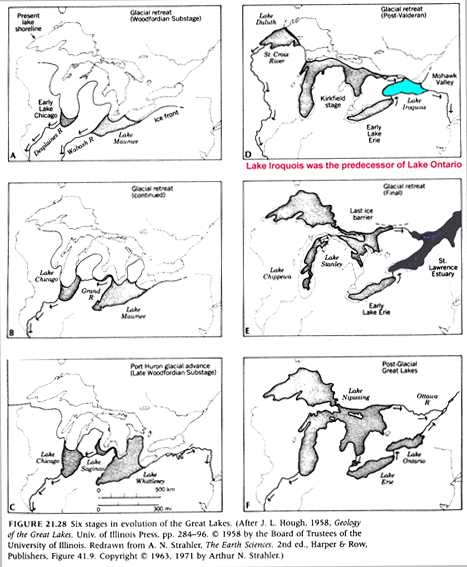
One result of this complex history of changing
lake levels and area extents is that today there are broad marginal zones of lake plains
along the shores of the Great Lakes. These plains are intensively developed as
agricultural lands and have absorbed the urban expansion of major cities around these
lakes. Many serious environmental problems beset the Great Lakes. One reason is that the
water supplies for all of us living there is that we all draw from the same lakes which
are fed, in return, enormous quantities of pollutant wastes. (J. L. Hough, 1958)
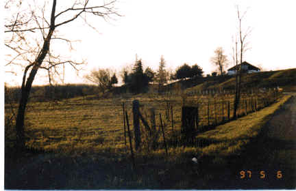
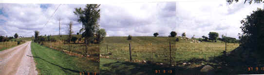
Lake Iroquois bluff at Hancock Rd.-the only one
left untouched by human hand that should be preserved for future generations.
SOME
HISTORY OF OUR AREA
From Oshawa "The Crossing between the
Waters" by M.McIntyre Hood:
Our watershed according to Hood ..." was
covered by a dense forest, through which there ran a broad streams.. Up to about the
beginning of the 18th century, the Indians were the only people who traversed the shores
of Lake Ontario. There were Indians of the Mississauga tribe, part of the Ojibway
nation...the Indians travel on foot through dense forest, along trails trodden bare by
their feet, and in canoes on the lakes and waterways...carrying furs ,first to Port
Credit...there they met the French, and later the English traders...around 1750. ...the
French established a trading post near the mouth of the Oshawa Creek... The district was
left undisturbed by the white man for about 30 years, until about the year 1790. It was
then that the white man was to make his first strong imprint on this area in and around
Oshawa, Whitby, Darlington. About that time, a road, known then and to this day as the
Kingston Road, was surveyed...by Governor-General Sir John Graves Simcoe...and the
district was beginning to be settled by the first white settlement. The first settlers,
Wilsons came from United States. They settled in the old abandoned log cabin left there by
the French traders.... It was the place later called Farewell Marsh (today Second Marsh)
and the Oshawa Creek (Oshawa harbor). These abounded in fur-bearing animals....creeks were
full of salmon...The location also appealed to B. Wilson as a place of great beauty,
although the passing of time has removed the forest and with it much of the natural beauty
of the scene...his daughter, Nancy Wilson, the first white child to be born in the
district... was also the first bride to be married to a settler...About 1794,...John
Pickell...arrived from Vermont to join the settlement,...other family...was the
Farewell...they came here after the American Revolution. One of them, Moody Farewell, who
was the pioneer of this family...farmed in Harmony district and opened a tavern there. He
carried despatches from Lynde's Tavern (Whitby) and Hartwell's Tavern (Newcastle). In
1816/17 Methodists began to evangelize the district; Moody became a member...he was a
Reformer, or Liberal, in politics; and was active, energetic from the time the party was
formed in 1824." After this family the Farewell Creek and Farewell Valley (formerly
called Toad's Hollow) was named.
References: Oshawa, "The Crossing
Between The Waters" by Hood Historical Atlas of Northumberland and Durham Counties by
Belden
 see
Cabins - History below for more
local history see
Cabins - History below for more
local history

[ Site Map ] [ Who We Are ] [ Black-Farewell ] [ Black Creek 2001 ] [ Local Wetlands ] [ What is a Wetland ] [ Our Watershed ] [ Map Links ] [ Current Events ] [ Studies ] [ MOEE Tips ] [ Photo Gallery ] [ Lake Iroquois ] [ Responsibility ] [ Govt. Contacts ] [ Enviro Links ] [ Message Forum ]
|